West Newton NCPs
Learn about West Newton/Highway 10 Neighbourhood improvements.
West Newton is the name of the community north of Highway 10 and west of King George Boulevard. Most of the area was built out gradually over the 20th century. The central part of West Newton, however, remained as large suburban lots and forested areas until recently.
The area was planned through three separate Neighbourhood Concept Plan (NCP) processes. Each plan provides direction on the type and density of development, road network, parks and engineering infrastructure for the neighbourhood.
The West Newton NCPs are largely residential, with a variety of park and institutional uses. They include J.T. Brown and Panorama Park Elementary Schools as well as Tamanawis Secondary. They are served by a number of neighbourhood parks, as well as the larger Tamanawis and West Newton Community Parks.
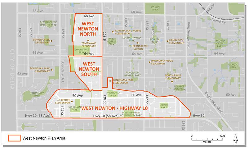
Plan Area
There are three plan areas in West Newton:
- West Newton North
- West Newton South
- West Newton - Hwy 10
These plan areas designate land uses for a large portion of the broader West Newton community, generally located south of 68 Avenue and north of Highway 10.
Background Information
In 1993 City Council identified West Newton as one of several areas that would be suitable for development consideration. A Local Area Plan was approved to serve as a guide for land use, servicing and development in the area. The Plan also identified the Neighbourhood Concept Planning (NCP) approach to further plan the north and south portions of the plan area.
In July 1995, Council approved the West Newton South NCP. This was the first phase of of the broader community. In July 1996, Council approved the West Newton North NCP to extend development north to 68 Avenue.
In 2002 Council received a delegation of land owners seeking the development of a new NCP in West Newton, along the north side of Highway 10. In April 2002, following a supportive petition process, Council endorsed Corporate Report R068 which authorized staff to proceed with a new NCP for the West Newton/Highway 10 area. In July, 2004, Council endorsed Corporate Report C007 which approved the West Newton/Highway 10 NCP.
Key Documents
West Newton / Hwy 10
West Newton North
West Newton South
Contact Information
Planning & Development
planningdevelopment@surrey.ca
604-591-4448
Are you considering developing or rezoning? The first step is a Pre-Application Meeting.