South Port Kells General Land Use Plan
Review the overall planning framework for the South Port Kells area of Guildford.
The South Port Kells General Land Use Plan (GLUP) establishes the vision for the broader Anniedale and Port Kells area. It provides an overall planning framework that will guide future servicing, development, and build-out of a comprehensively planned community. The plan is also used to guide the preparation of Neighbourhood Concept Plans (NCPs) in South Port Kells. NCPs provide more detailed level planning for each future neighbourhood.
The following NCPs have been completed within the South Port Kells area:
A Neighbourhood Concept Plan (NCP) for Port Kells has not yet been initiated.
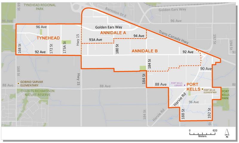
Plan Area
South Port Kells encompasses an area of approximately 608 hectares (1,500 acres), extending from Highway 1 in the north to 168 Street in the east, Port Kells Park in the east and the Agricultural Land Reserve in the south.
Background Information
In April 2003, Council endorsed Corporate Report R063 which authorized staff to initiate the preparation of a General Land Use Plan for the South Port Kells area. In support of the planning process staff established a Citizen Advisory Committee ("CAC") and undertook a series of community meetings and workshops.
In March 2005, Council endorsed Corporate Report C002 which provided an update on the process and authorized staff to present to the public the "preferred" General Land Use Concept Plan for South Port Kells. Council also directed staff to seek additional community input on the policies and engineering strategies related to the preferred plan.
In May 2005, Council endorsed Corporate Report C010 which approved the South Port Kells General Land Use Plan. The General Land Use Plan is a culmination of a one and one-half year planning and community consultation process. The resulting plan document reflects the ideas, suggestions and input received from the community, with review and input from the South Port Kells Citizen's Advisory Committee ("CAC"). It also reflects requirements and technical input by government agencies, the Surrey School District, environmental, heritage, and engineering consultants, and other stakeholders. The General Land Use Plan consists of a land use concept, policies related to the land use concept, and generalized engineering servicing strategies for the South Port Kells area.
Following the completion of the general land use plan, Council endorsed Corporate Report R107 which authorized staff to proceed with the preparation of a Neighbourhood Concept Plan (NCP) for South Port Kells Area A - Anniedale.
Background Reports
Key Documents
Contact Information
Planning & Development
planningdevelopment@surrey.ca
604-591-4448
Are you considering developing or rezoning? The first step is a Pre-Application Meeting.