East Panorama Ridge
Review the plan for a small business park on the south side of Highway 10 in East Panorama Ridge.
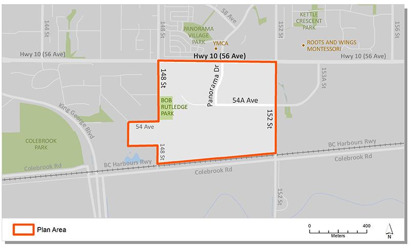
East Panorama Ridge NCP is the name of a business park in South Newton, along the Highway 10 truck route. The plan, which also includes some residential transition areas along its eastern border, is also home to Bob Rutledge Park.
The plan provides direction on the type and density of development, location and extent of the transportation network, engineering infrastructure and the interface between business park use and the existing adjacent residential neighbourhoods.
Plan Area
The East Panorama Ridge Plan Area comprises approximately 52.7 ha (130 acres) of land and is generally bounded by Highway 10 to the north, Colebrook Road to the south, 148 Street to the west, and 152 Street to the east.
Background
In early 2000, the City initiated a planning process for the area, which included two public open houses and resident surveys. In July, 2000, Council endorsed Corporate Report C009 which approved the preferred option for the land use plan.
In 2002, the City undertook a further detailed review of the plan area to address some technical issues related to road location and topography, landscape buffer requirements for non-residential uses, expansion of Bill Rutledge Park and other opportunities related to the business park uses. In March 2002, Council endorsed Corporate Report L003 which approved an amendment to the existing land use plan.
Key Documents
Contact Information
Planning & Development
planningdevelopment@surrey.ca
604-591-4448
Are you considering developing or rezoning? The first step is a Pre-Application Meeting.