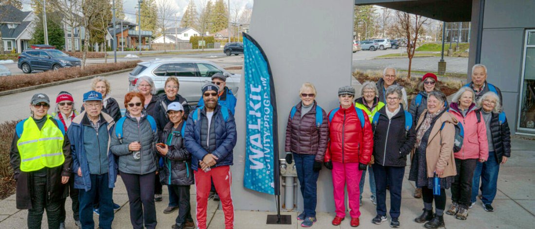
WALKit
Walking is a great way to get around, explore our city, and help achieve your fitness goals. Join us for a walk, or use our web map to explore new pedestrian routes in your neighbourhood!
Get moving, meet new people, and learn about various areas and topics of interest through the WALKit program. We offer free guided walks for:
-
Ages 55+: Wednesdays, year-round
-
All ages: Every other Saturday between May and October
Can't meet up? Use our interactive WALKit Web Map to explore pedestrian routes across Surrey.
This program is one of six partnering organizations of the Surrey Intercultural Seniors Social Inclusion Partnership Network funded by the Employment and Social Development of Canada under the New Horizons for Seniors Program.
WALKit Activity Program: 55+
Join us for our group walks on Wednesdays to work on mobility, meet new people, and chat about different points of interest along the way. Hosted year-round.
Cloverdale Greenway
April 24 at 10am-11:30am and 12pm-1:30pm
Join us for a walk on the Cloverdale Greenway. Experience this peaceful nature walk in an urban setting.
Cloverdale Recreation Centre
Crescent Beach Walk
May 1 at 10am-11:30am and 12pm-1:30pm
Join us on this local nature walk in Surrey's only beach community! Explore the walking trails in Blackie Spit Park. Check out the Dunsmuir Community Garden. Walk the gravel promenade pathway that runs next to the beach. Check out the sights and sounds of the ocean.
Blackie Spit
Fleetwood Walk
May 8 at 10am-11:30am and 12pm-1:30pm
Join us on this local nature and urban walk that will highlight local community services and programs. Learn about the history of Francis Park and explore local landmarks such as the gardens and labyrinth in Fleetwood Park.
Fleetwood Community Centre
Kwomais Nature Walk
May 15 at 10am-11:30am and 12pm-1:30pm
Experience nature and history as you explore one of the local parks and neighbourhoods in South Surrey. Some key points of interest on this walk will include, a labyrinth and the Ocean Park Hall built in 1925.
Kwomais Point Park
Bear Creek Park Nature Walk
May 22 at 10am-11:30am and 12pm-1:30pm
Walk in one of Surrey's most popular parks. Explore the nature trails that wind through meadows and forests. Lookout for owls, eagles, ducks, aquatic insects, frogs, and salamanders.
Bear Creek Park
Serpentine Greenway Walk
May 29 at 10am-11:30am and 12pm-1:30pm
Join us for a walk on the Serpentine Greenway in Newton. Experience nature in an urban setting while learning about activities offered at Newton Athletic Park.
Newton Athletic Park
WALKit Activity Program: All Ages
Surrey offers more than 800 parks—200 with amenities for people and 600 more to protect natural areas, open space, and biodiversity. Join us to explore some of these parks in your community. Offered between May and October.
Bear Creek Park Nature Walk
May 4 at 10am-11:30am
We are hosting a special WALKit in collaboration with the Jane’s Walk Festival. The Jane’s Walk Festival is an international festival of free, citizen-led walking tours that take place in over 200 cities around the world. Jane’s Walks encourage people to share stories about their neighbourhoods, discover unseen aspects of their communities, and use walking as a way to connect with their neighbours.
Walk in one of Surrey's most popular parks. Explore the nature trails that wind through meadows and forests. Lookout for owls, eagles, ducks, aquatic insects, frogs, and salamanders.
Bear Creek Park
WALKit Web Map
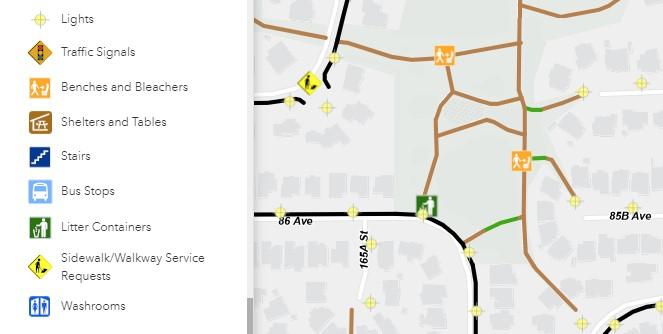
Use the web map to get a detailed overview of pedestrian routes across Surrey, including routes that are age friendly. Plan your preferred route and enjoy a stroll outdoors. You can meet new people, get some fresh air and exercise.
How to Use the Map

Zoom in and out
Zoom the map in (objects appear larger), or zoom the map out (objects appear smaller). Alternatively you can use two fingers on a smart phone or other touch screen device to zoom in or out.

Locate me
Orients your current location to the center of the map. You may be prompted to allow experience.arcgis.com to know your location. Select Allow if you want the map to locate you.

Search
Type in things to search and pick from the list of suggestions provided. For example: type in Newton to see options to choose from. Map will zoom to selected item.

Layers/Legend
See the Layer List or the Legend. The Layer List provides four layers of information on the map that a you can toggle on or off. The Legend describes content of map.

Toggle Aerial
Change the background of the map between map view or aerial photo view.

Draw
Create simple markup graphics in the form of points, lines and polygons and choose from a variety of colours and templates. You can also display measurements with your choice of units. These graphics will remain on the app until the browser is closed/refreshed.

Print the current map view by connecting the app to your local printer or saving the image as a file on your mobile device.
Leave Feedback About Your Walking Route
Leave feedback about your walking experience and report a problem if your walk was not satisfactory. Click on the arrow button on the left side of the screen to view the feedback form. Your feedback could help prioritize future route improvements.
About this Project
This project is made possible through the Surrey Intercultural Senior Social Inclusion Partnership Network (SISSIPN) a collective impact initiative funded by the Employment and Social Development Canada under the New Horizons for Seniors Program and includes six organizations: Progressive Intercultural Community Services (PICS); City of Surrey, Seniors Come Share Society; SOURCES BC; Semiahmoo House Society; and Fraser Region Aboriginal Friendship Centre Association (FRAFCA).
Trails & Parks
If you prefer walking through the forest or surrounded by nature and wildlife, check out:
Walking Tracks
If you're looking for cushioned walking tracks, check out the walking tracks at:
- Bear Creek Park (adjacent to Surrey Arts Centre)
- Newton Athletic Park
- South Surrey Athletic Park
- Guildford Recreation Centre (Indoors. Drop-in admission required)
Walking Groups
Walking with others is a great way to catch up with family and friends while also getting fresh air and exercise. There are also numerous walking groups in Surrey for anyone looking to get out and meet new people.
Check out the following resources to find a group near you:
- Surrey Trekkers Volkssport Club
- Guildford Town Centre Walking Club
- Meetup for Walking Groups
- Semiahmoo Walkers
- WalkBC
Know of a walking group not on this list? Please contact cityofsurrey@surrey.ca
Charity Walks
Walk for a great cause at an upcoming charity walk in Surrey:
Sign up for a Charity Walk near you:
- Run Surrey Run
- Coldest Night of the Year
- Walk with Your Doc
- Terry Fox Run
- The Father's Day Run
- Child Development Foundation
- CIBC Run for the Cure
- CDSS Walk for Awareness
- Sun Life Walk to Cure Diabetes
Know of a charitable walk not on this list? Please contact cityofsurrey@surrey.ca
Self-Guided Walks
For scenic walks that take you past public art, gardens, or the waterfront, check out:
Walking Plan
Download the Surrey Walking Plan to read more about our goals for improvements across the city.
Greenways Plan
Review our Greenways Master Plan to discover our multi-use pathways for pedestrians.
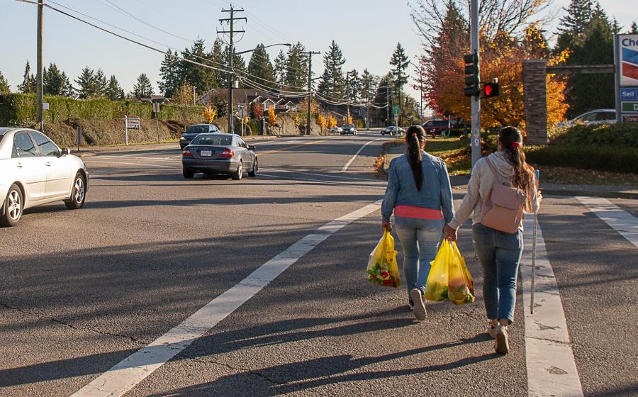
Walking Safety Tips
We want you to stay safe while walking. Follow these tips: