Aloha Estates NCP
Review the land use plan for Aloha Estates, part of the broader East Clayton neighbourhood.
Aloha Estates is the name of a small neighbourhood in East Clayton. The area was originally exempted from the broader East Clayton NCP process. In 2013, based on development interest within Aloha Estates, Council authorized the preparation of a concept plan for the area. The 1999 Clayton General Land Use Plan provided a guide for the development of this land use processes.
The Aloha Estates plan provides direction on:
- the type and density of development,
- parks and community amenities,
- and engineering infrastructure
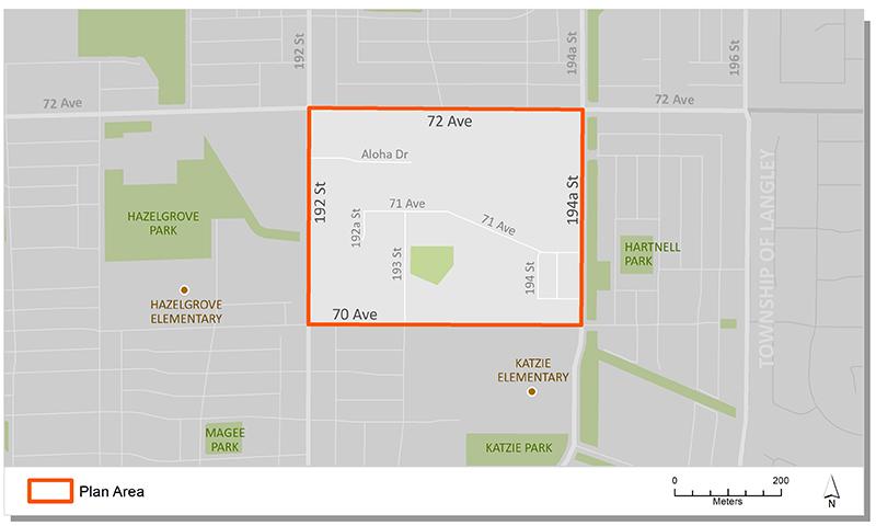
Plan Area
Aloha Estates is bounded by 72 Avenue to the north, 70 Avenue to the south, 192 Street to the west and 194A Avenue to the east, with a total area of 17.5 hectares (43 acres).
Background
In 1996 City Council identified Clayton Heights as one of several areas of the City that would be suitable for new development. A General Land Use Plan was approved in 1999 to serve as an overall guide for land use, servicing and development in the area. The Plan presented a vision for sustainable growth, efficient development and a compact livable community. It also identified the Neighbourhood Concept Planning (NCP) approach to plan future Clayton Neighborhoods.
In 2003, following an integrated and comprehensive community consultation process, Council approved the East Clayton NCP, the first neighbourhood phase of Clayton Heights. At the time, the landowners in Aloha Estates preferred not to redevelop and remained as larger acreage.
In 2013, based on renewed development interest within Aloha Estates, Council authorized the preparation of a concept plan for the area. In October 2013, Council approved Corporate Report R219 which approved the Aloha Estates Plan.
Key Documents
Contact Information
Planning & Development
planningdevelopment@surrey.ca
604-591-4448
Are you considering developing or rezoning? The first step is a Pre-Application Meeting.