North Cloverdale
Review the land use plans that guide neighbourhood development in North Cloverdale neighbourhood.
North Cloverdale is the name of the neighbourhoods along the eastern ALR escarpment, south of Fraser Highway and north of 64 Avenue. The area is separated into two plan areas, each of which was planned through separate NCP processes. These two North Cloverdale land use plans, now largely built out, provide direction on the type and density of development, urban design, parks and community amenities and engineering infrastructure.
Plan Area
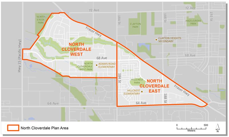
The North Cloverdale plan area is divided into two NCPs, east and west of 184th Street. Combined they encompass about 192 hectares (476 acres), extending from the ALR in the west to 192nd Street in the east.
Background Information
In March, 1993, City Council approved a Local Area Plan for North Cloverdale. The approved Plan identified two neighbourhoods (east and west), generalized land uses and development policies for the area. Council also approved the Neighbourhood Concept Planning (NCP) approach to further plan the east and west portions of the North Cloverdale community.
In September, 1994, Council approved the North Cloverdale East NCP, the first phase of North Cloverdale. Then, in July 1995, Council approved the North Cloverdale West NCP to complete neighbourhood planning for the area.
Key Documents
North Cloverdale East
North Cloverdale West
Contact Information
Planning & Development
planningdevelopment@surrey.ca
604-591-4448
Are you considering developing or rezoning? The first step is a Pre-Application Meeting.