Anniedale Tynehead NCP
We're creating a new plan for Anniedale Tynehead that will support development while protecting the environment.
Plan update
In November 2023, Council authorized staff to update the Anniedale Tynehead plan. The existing plan, created in 2012, needs an update to address current challenges and guide new development. The update will integrate the ongoing work to update the West Amendment portion of the plan.
Plan area
The plan area covers approximately 408 hectares (1008 acres) of North East Surrey. It is generally bounded by Highway 1 and 96 Avenue in the north, 168 Street in the west, the Agricultural Land Reserve (ALR) in the south and Harvie Road in the East.
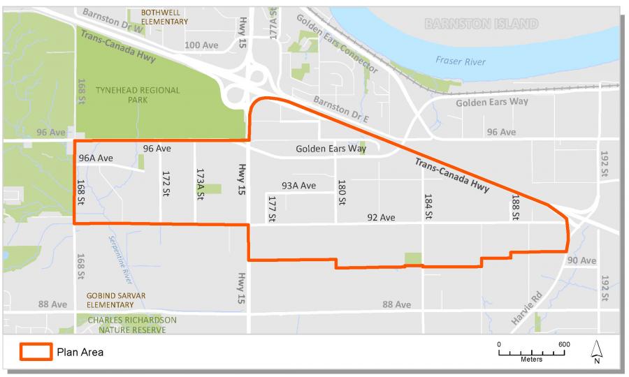
Anniedale Tynehead is the name of a large neighbourhood in east Guildford, located north of the Agricultural Land Reserve (ALR) and south of Highway 1. Originally characterized by its rural acreage lots and agricultural uses, the area is now designated to support urban development and the future home of up to 20,000 Surrey residents.
Situated over gently sloping highlands, the area provides excellent views of the agricultural lowlands. It is also home to many significant and protected watercourses, including the Serpentine River and several of its tributaries.
Background information
In 2003 City Council identified South Port Kells as an area of the City that would be suitable for new development. A General Land Use Plan was approved in 2005 to serve as an overall guide for land use, servicing and development in the area.
The Plan presented a vision for a complete community with local commercial nodes, employment lands, a mix of residential uses and densities and a variety of new community amenities including schools, parks, pathways and natural areas. It also identified the Neighbourhood Concept Planning (NCP) approach to plan future neighborhoods.
In 2009, Council endorsed Corporate Report R034 which approved an NCP process for the combined areas of Anniedale "A," Anniedale "B," and Tynehead within the South Port Kells General Land Use Plan.
In October 2010, following a comprehensive community consultation process, Council endorsed Corporate Report R212 which approved the draft land use plan. Council also authorized staff to complete the plan, including the completion of an engineering servicing plan, design and development guidelines and further refinements to the transportation, parks and land use concepts.
In April 2012, Council endorsed Corporate Report R077 and Corporate Report R087 which approved the land use and engineering servicing components of the final (Stage 2) Anniedale Tynehead NCP. In July 2012 Council endorsed Corporate Report R152 which approved servicing and by-law amendments necessary to implement the plan.
In July 2022, Council approved Corporate Report R156 which endorsed a Stage 1 Land Use Concept for a portion of the Anniedale Tynehead NCP, including changes to land uses, transportation network, and parks and open spaces. Council also authorized staff to proceed with processing of development applications in the NCP Amendment area on the basis of conformity with the Stage 1 Land Use Concept and that the final approval of such applications be held pending completion of the Stage 2 component of the NCP review.
Background studies
- Environmental Assessment Report (September 2009)
- Environmental Assessment Report Addendum Letter (June 2010)
- Anniedale-Tynehead NCP Area Wetland Inventory and Watercourse Assessment (October 2020)
Key documents
Contact information
Jack Shi, Planning Analyst
jack.shi@surrey.ca
604-592-2640